RRINR technical reports

Glaciers on earth develop when snow and ice accumulate in polar and northern regions and areas of high elevation during winter seasons more than that which is melted during the summer seasons. Over tens of thousands of years, this phenomenon results in the formation of alpine glaciers and massive continental ice sheets. Eventually as the depth and size of ice sheets increase, the ice flows out in a radial manner away from centers of greatest accumulation and particularly toward temperate regions further south. As glaciers move over the land, they change the character and topography of the land. The work of early glaciers is modified by the glaciers that follow. Hence, the study of glacier movements and the deposits left behind is a complex science.
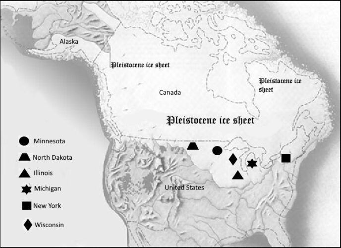
Three major stages of Pleistocene glaciation are identified by geologists in North America: pre-Illinoian (2.5 million-300,000 years before present); Illinoian (190,000-130,000 years before present); and Wisconsin (75,000-11,700 years before present). Long interglacial periods interrupted periods of glaciation.

Earth’s temperature was much colder during periods of glaciation. During the late Wisconsin Stage, the average global temperature was about 46° Fahrenheit or 11° colder than the average global temperature for the 20th century (Tierney et al., 2020). When glaciers reached Columbus, Ohio, the mean daily temperature for July was 20° Fahrenheit colder than the mean daily temperature of 75° for July at the Columbus weather station in the early 20th century (Goldthwait, 1959). In North American, estimates indicate that when mean annual temperatures decreased in the range of 4° to 7° Fahrenheit the climate was favorable for formation of glaciers.
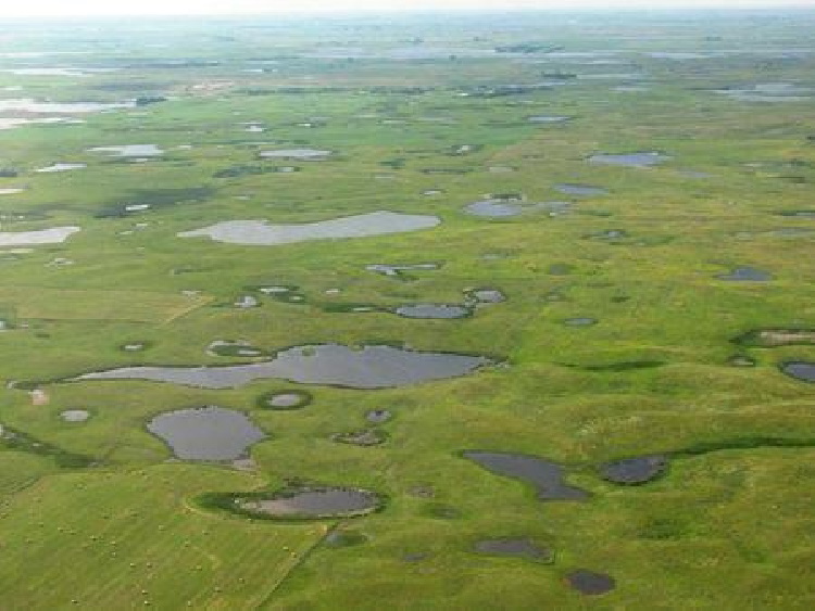
Glacier had a major impact on the land in North America, altering the landscape in ways like no other force on earth. Topographies on land and near the sea changed in significant ways. Thousands of lakes were created over large areas and wetlands formed in areas of low terrain. In Minnesota, glacial outwash plains are a common feature and peat bogs cover thousands of aces. A huge glacial Lake Agassiz once covered a large area in northwest Minnesota.
As glaciers advanced and retreated, landforms unique to glacial landscapes were created. In some areas, elongated hills called drumlins rise as much as 100 feet or more above surrounding terrain. As ice sheets melted, water flowing in channels within the ice created a feature called eskers, narrow, winding ridges consisting of sediments that are often sorted. Near margins of ice sheets, terminal moraines formed. More generally, after the ice sheets melted, debris carried by the ice was deposited over vast areas as ground moraine.
Glaciers also had a major and long-term impact of ecology of all regions on earth. The atmosphere and oceans changed too. As some scientists suggest, during the era when glaciers advanced, earth was a vastly different environment for most species, both plant and animal, than currently.
The massive ice sheets advanced slowly across the land, moving in the range of 500 to 600 yards each year. A recent interesting study indicates that ice retreated at the rate of 42-65 yards per year in northeast Minnesota and adjacent Canada (Lowell et al, 2021). That the ice sheet retreated from Minnesota as recent as 11,500 years ago, and even more recently in areas further north, is remarkable.
Three conditions can lead to global cooling and the formation and growth of glaciers:
• Changes in solar energy reaching different areas of the earth’s surface
• A lack of sufficient greenhouse gases in the atmosphere, allowing easy escape of solar energy back to space
• Reflection of solar energy back to space due albedo affect
Studies on the cause of the Ice Ages focus on changes in the earth’s tilt on its axis of rotation (obliquity) and wobble (axial precession) as it rotates. A Shift of the earth’s orbit from a circular path to an elliptical path (eccentricity) as it moves around the sun is a factor that influences the amount of solar energy reaching earth. These movements (called cycles), first set forth by Serbian scientist Milutin Milankovitch, affect the distribution of solar energy on the earth’s surface and to a lesser degree, in the case of eccentricity, insolation reaching earth.
As for tilt on its axis of rotation, tilt varies between 22.1° and 24.5° on a 41000-year cycle. When tilt is smaller, the conditions are right for glaciers to form, when greater glaciers retreat and melt, according to Alan Buis, NASA Jet Propulsion Laboratory. Since the current tilt is 23.4° this suggests earth is at about mid-point between glacial formation and glacial retreat. But now is moving in a direction of smaller tilt favorable for glaciers to form.
As greater forces related to earth-sun relationships play out, glaciers are influenced by many factors on or near the surface of the earth (including the atmosphere), such as the carbon cycle, circulation of air masses, chemistry of the oceans, and movement of ocean currents.
Over thousands of years, the earth’s carbon cycle was changed and disrupted. The adverse climate during glacial periods forced decline of forests and slowed removal of carbon dioxide from the atmosphere. Millions of square miles of land, exposed in coastal areas after sea levels dropped, likely released carbon stored in organic materials in coastal soils back to the atmosphere. Climate fluctuated in small degrees from warmer to cooler and conversely, in part, due to changes in carbon dioxide in the atmosphere as glaciation progressed.
Glaciers caused the rise and fall of sea levels. During periods when glaciers expanded, billions of cubic meters of water were removed from the oceans and distributed over the land as snow which eventually turned into ice. During the recent glacial maxima in North American, the sea level decreased by 400 feet, causing a huge area of land beneath today’s Bering Sea to become open, barren land. All coastal areas around the world were similarly impacted.
When the glaciers melted, the fresh water from melting ice returned to the oceans, and sea level rose. Areas that were once barren land became inundated by rising waters. The magnitude of this shift is great. One estimate predicts that ocean levels would increase 600 feet if all the ice on earth following a period of maximum glacial growth melted. Indeed, since the latest glacial advance, sea levels have risen about 400 feet. If the glaciers in Greenland and Antartica melted, sea level would rise an addition 215 feet, according to NASA.
When glaciers reached their maximum in North America, ice accumulated to depths of two miles or more and covered vast areas of the continent. This places the upper surface of glaciers in the same league as the highest mountain ranges in the United States. At high elevations, the atmosphere is very cold. And due to the albedo effect of ice, reflecting sunlight back into the atmosphere, cold at the surface of the earth intensifies. Winds flowing down from continental glaciers undoubtedly created harsh weather at margins of ice sheets and this affected climate more generally.

As glaciers increased in size, the abundance and distribution of plant and animal life were severely affected. Huge swaths of trees and other vegetation in the Northern Hemisphere completely disappeared, buried beneath millions of square miles of ice. Vegetation away from the margins of glaciers did not fare well either. Plants and animals had to adapt to changing climatic conditions or go extinct. Only fossils of the woolly mammoth, American mastodon, and saber-tooth cat remain today.

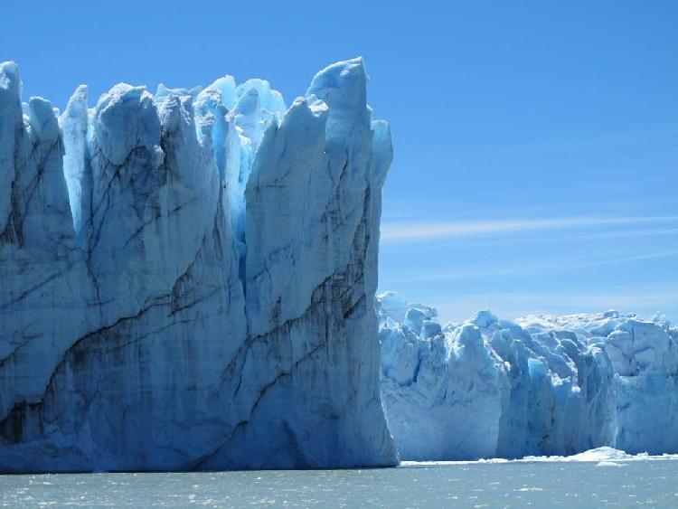
Putting global climate in perspective, vast areas of the earth are still covered by massive ice sheets. Antarctica and Greenland are two prime examples. Even in more temperate regions, glaciers still flow in Alaska and as far south as Glacier National Park in the United States. Robert M. Krimmel gives an excellent account in a publication Glaciers in North America (U.S. Geological Survey Paper 1386-J-2). In the Americas, active glaciers are also found at high elevations in Los Parque Nacional Los Glaciares in southern Argentina.
Glaciers from the past influence human activities today. Farmers in north-central areas of the United States know what it’s like to live on lands once covered by glaciers. Even on small tracts, as little as 160 acres, wetlands, areas of glacial outwash, low hills of unsorted till (with an abundance of stones mixed in), and sand plains, transition from one to another in distances measured in yards. Planning for productive crops is a major challenge under these conditions.
References Cited:
Abdelrady, Ahmed, Joris Timmermans, Zoltán Vekerdy, and Mhd. Suhyb Salama. 2016. “Surface Energy Balance of Fresh and Saline Waters: AquaSEBS.” Remote Sensing. 8 (7): 583.
Goldthwait, Richard P. 1959. “Scenes in Ohio During the Last Ice Age.” Ohio Journal of Science 59 (4): 193-216.
Lowell, Thomas V., Meredith A. Kelly, Jennifer A. Howley, Timothy G. Fisher, Peter J. Barnett, Roseanne Schwart, Susan R.H, Zimmerman, Nathaniel Norris, and Andrew G.O. Malone. 2021. “Near-Constant Retreat Rate of a Terrestrial Margin of the Laurentide Ice Sheet During the Last Glaciation.” Geology 49 (12): 1511-1515.
Tierney, Jessica E., Jiang Zhu, Johnathan King, Steven B. Malevich, Gregory J. Hakim, and Christopher J. Poulsen. 2020. “Glacial Cooling and Climate Sensitivity Revisited.” Nature 584: 569-573.
Suggestions for further reading:
Macdougall, Doug. Frozen Earth: The Once and Future Story of ice Ages. Oakland, Calif.: University of California Press, 2013.
Sharp, Robert P. Living Ice: Understanding Glaciers and Glaciation. New York: Cambridge University Press, 1988.
ABOUT THE AUTHOR
John Sandy, author of this technical report, is former head of Rodgers Library for Science and Engineering, The University of Alabama. He also was head of the Natural Resources Library, Natural Resources Research Institute, University of Minnesota Duluth, 1984-1991.
Copyright © 2022 John Sandy
Permanent link to digital copy of this technical report: https://ir.ua.edu/handle/123456789/8472


