RRINR technical reports

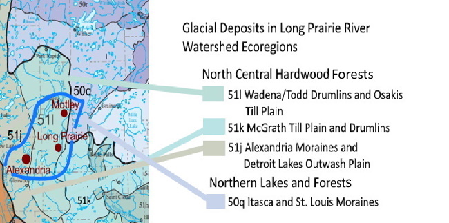
The Long Prairie River begins at Lake Carlos, north of Alexandria, Minnesota, and flows mostly in a west to east direction until it reaches the town of Long Prairie. At Long Prairie the river makes a sharp turn to the north and miles downstream from Long Prairie empties into the Crow Wing River near Motley, Minnesota. The Crow Wing River joins the Mississippi River several miles east Motley.
The river is part of the Long Prairie River Watershed, a geographic area which encompasses 883 square miles of land. A few major tributaries provide drainage for this area before emptying into the river’s main channel. The main tributaries are Eagle, Dismal, Spruce, Turtle, Moran, and Fish Trap creeks.
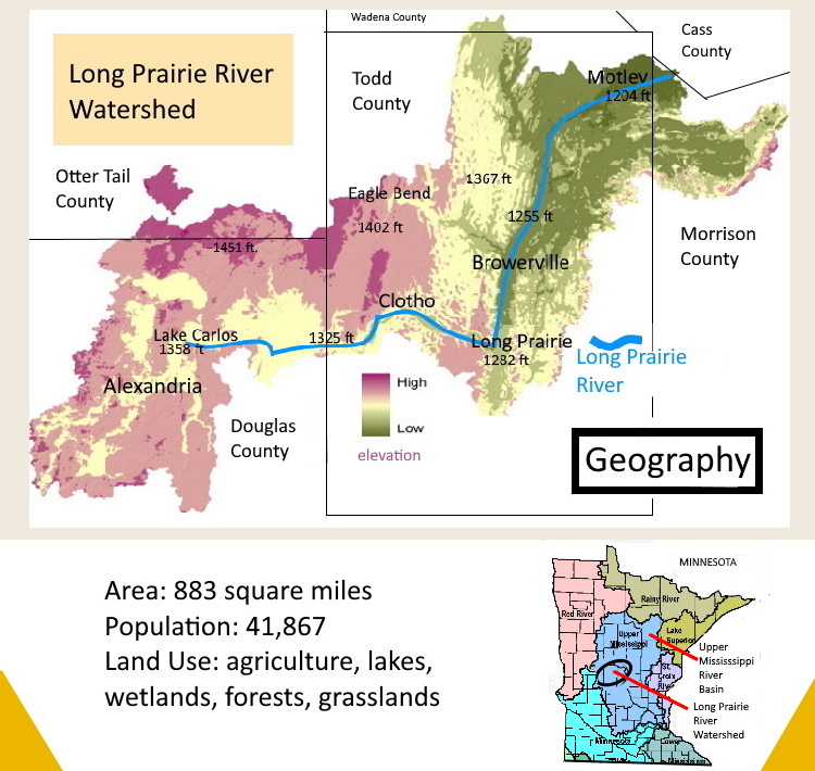
Glacial deposits are the foundation of the current landscape. Glaciers moved over the land and deposited glacial sediment composed mostly of glacial till (unsorted deposits). In an area near the center of the watershed, a glacier created drumlins, a special type of landform. The drumlins appear on the land as large, elongated hills and are aligned in the direction the glacier moved. Kames, high mounds of mostly sand and gravel, are found in some areas. Massive volumes of water flowing away from margins of the ice created local outwash plains, consisting of sand, gravel, and silt.
Three glaciers played a key role in forming the landscape of the watershed. An early ice sheet (from 75,000 to 35,000 Years ago) called the Wadena Lobe flowed from the north into Todd County. The huge area of drumlins across the center of the watershed and the Alexandria moraine were formed by the Wadena Lobe. A second ice lobe, the Superior Lobe, advanced from the east 16,000 years ago and formed the St. Croix moraine in eastern Todd County. Finally, the Des Moines Lobe, a later glacier in the area as recent as 12,000 years ago, affected the landscape in the southern and southwestern part of the watershed.
Post-glaciation, as the landscape matured, a new system of drainage developed across the watershed. The Long Prairie River, along with small tributary streams, became the path for water from annual rainfall to move out of the watershed toward the Mississippi River.
Due to the irregular surface of the glacial till on the land, marshlands and lakes filled areas of lower topography. In terms of geology, the watershed has a youthful topography. Thousands of years into the future, erosion will cause lakes and wetlands to fully integrate with the network of streams and rivers in the watershed.
The length of the Long Prairie River is about 96 miles, measured along the stream’s channel. Over its course, segments of the river are in Douglas, Todd, and Morrison counties. Along its path from Lake Carlos to the Crow Wing River, the elevation of the river drops from 1,358 feet to 1,204 feet. The river’s channel is narrow, generally less than 60 feet.
East of Lake Carlos, the river flows at an elevation of 40 feet or less below the bordering uplands. From Clotho, east, the river occupies a spectacular valley. Downstream from County Road 11, the river flows as much as 120 feet below bordering uplands which rise over 1,400 feet on the north and south side of the river. North of the town of Long Prairie the landscape changes in character. The valley widens and elevation of the bordering upland on the west is higher than the upland to the east.
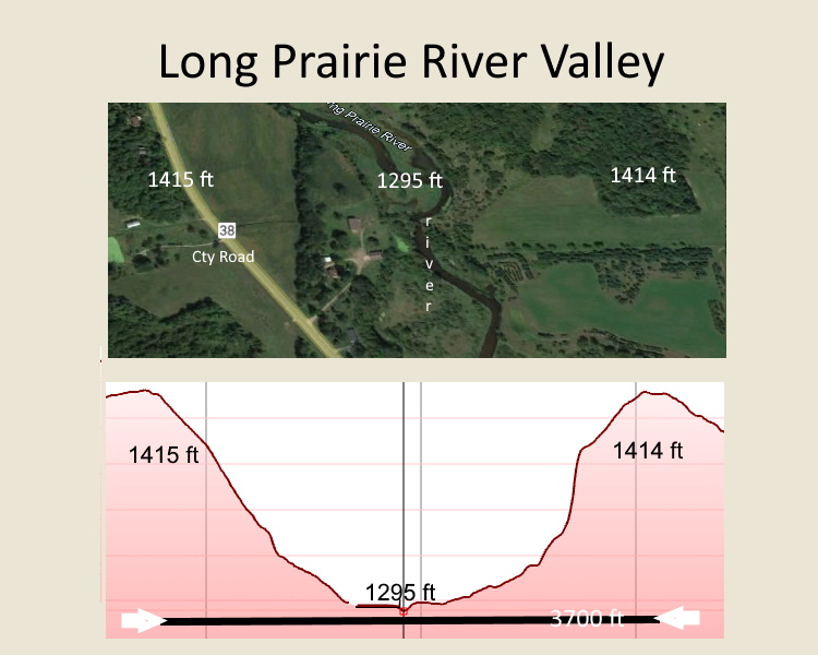
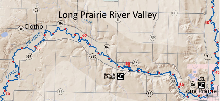
Marshlands are found along the river’s channel. The main channel and marshlands together range in width from about 100 feet east of Lake Carlos to about 1,000 feet east from Clotho. Downstream from the town of Long Prairie, the width increases to 1,500 feet or more in some areas.
Tall grasses and other aquatic-tolerant vegetation grow in the marshlands. And riparian forests are found near the river’s channel on dryer land. The combination of riparian forests and marshlands make ideal habitat for birds and mammals.
A wide sand plain borders the river and marshlands in some areas. The plain is used for agriculture, often planted to corn and, in a few cases, potatoes. Due to porosity of the sandy soil on the plain, irrigation is necessary to get high crop yields.
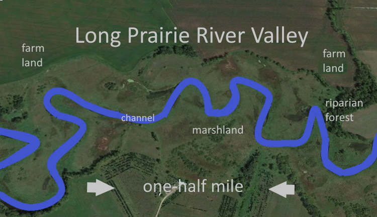
During the time glaciers advanced into central Minnesota in the late Pleistocene, the direction of flow for a segment the Long Prairie River was different than what exists today. Thousands of years ago, a large river flowed from north to south from the Motely area to Long Prairie and continued south towards Sauk Centre. At some point, this ancestral river reversed its direction to flow from south to north.
Geologists discovered that the south flow direction of the ancestral Long Prairie River was reversed to the north when ice from the Des Moines Lobe (16,000 to 12,000 years before present) blocked the river several miles south of the town of Long Prairie. The ice created a dam forcing the river to find a new outlet to the north in the direction of Motley. An esker is still visible on the land north of Little Sauk marking the location of the dam.
A traveler going south from the town of Long Prairie will notice a long, wide, flat prairie. This prairie formed from glacial outwash coming from the Des Moines Lobe, which moved into the area from the southwest. The glacial outwash fills a valley created earlier by the ancestral Long Prairie River that flowed south from Motely toward Sauk Centre. The current Long Prairie River from Lake Carlos to the town of Long Prairie was likely a tributary of the ancestral river, joining the north-south flowing ancestral river at Long Prairie.
In most years, the volume of water in the river increases greatly in early spring, in April, due to melting of snow accumulated over the winter. Water from melting snow fills tributaries on the upland and numerous small streams, then flows into the river’s main channel. By summer, the volume of water in the river is greatly diminished. The fall season generally brings more water to the river. Depending on the season and local conditions of heavy rainfall or drought, at any time, the level of the river may rise or fall, resulting in more or less water in marshlands and the river’s main channel.
The Long Prairie River Watershed fits within in two distinct ecoregions: The North Central Hardwood Forests ecoregion and the Northern Lakes and Forests ecoregion. The former encompasses almost all the watershed, except for a small area in the northeast. Basically, from about ten miles northeast of Browerville, the North Central Hardwoods ecoregion transitions to the Northern Lakes and Forests ecoregion.
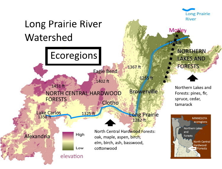
The upland forest is mainly hardwoods, such as red and bur oak, sugar maple, red maple, elm, aspen, paper birch, basswood, and green ash. On river bottom land hardwoods such as silver maple, black ash, and cottonwood are common. White pine, red pine, jack pine, balsam fir, white and black spruce, red and white cedar, and tamarack are found in many areas in the northeast part of the watershed.
Land use across the watershed exhibits great variety. Farmland is mixed with forests, lakes, and wetlands. About 22.5% of the river’s watershed is forest, 27.5% grassland (including pasture), 26.6% row crops, 8.1% wetlands, and 7.5% open water, according to the Natural Resources Conservation Service, USDA (see map at end of this post). By one estimate, 220 lakes are present, most located in the western and eastern parts of the watershed.
A wide range of crops are grown, mainly corn and oats. Considerable upland acreage is planted to alfalfa and other hay crops for livestock. Much acreage on the upland is used as pasture for dairy and beef cattle. Potatoes are grown in some parts of the valley.
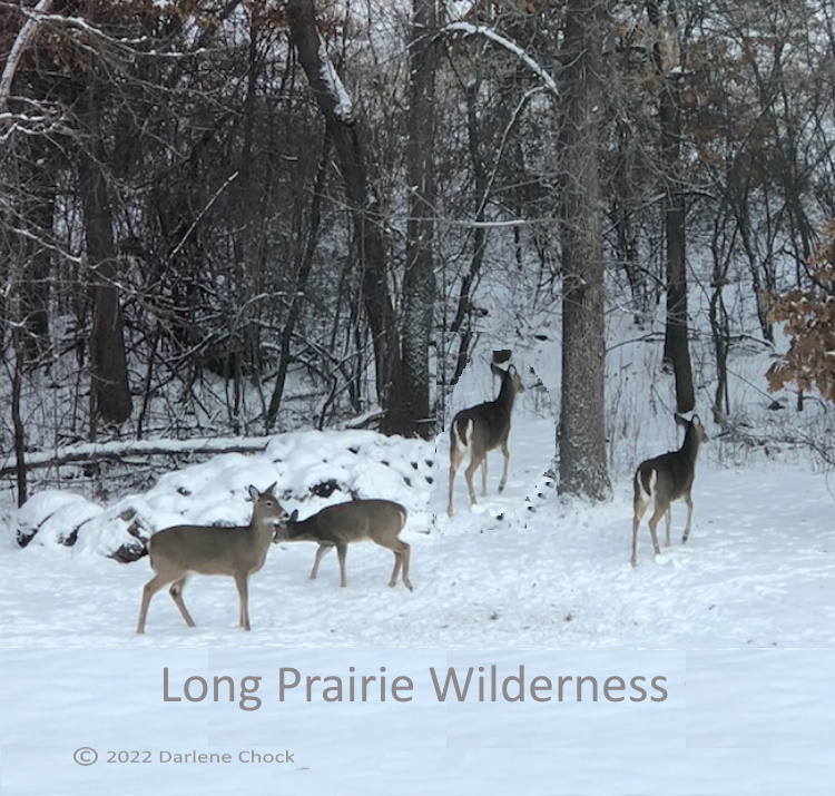
The Long Prairie River Watershed has a variety of wildlife. Raccoon, white-tailed deer, gray and red squirrels, and fox are abundant. Mink, muskrat, river otter, and beaver are present, in limited numbers, along the river. In recent years, bald eagles, pheasants, and wild turkeys have recovered and are found in many areas of the region.
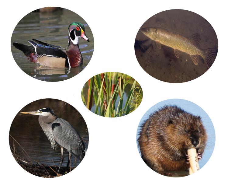
Several species of songbirds find suitable habitat in the river’s valley and on the uplands. Mallard, wood duck, and great blue heron are found near and on the river. Northern pike, walleye, white sucker, bullhead, and shorthead redhorse are common species of fish in the river.
The Long Prairie River offers some recreational opportunities. A trip down the Long Prairie River on a small watercraft is an enjoyable experience. To promote this activity, The Minnesota DNR has designated the Long Prairie River as a water route for canoeists.
The stretch of river between the town of Long Prairie and Clotho, on either County Road 38 (south side of river) or County Road 86 (north side of river), offers special opportunities to view nature at its best. This is also an ideal area to capture photos of wildlife and magnificent landscapes.
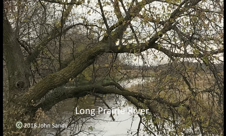
Land in the Long Prairie River Valley is privately owned, with minor exceptions. Farmers who own land bordering the river may give permission, if asked, and allow visitors to reach the river by crossing agricultural lands. Only five public carry-in access points are available to place small watercraft or rafts in the river.
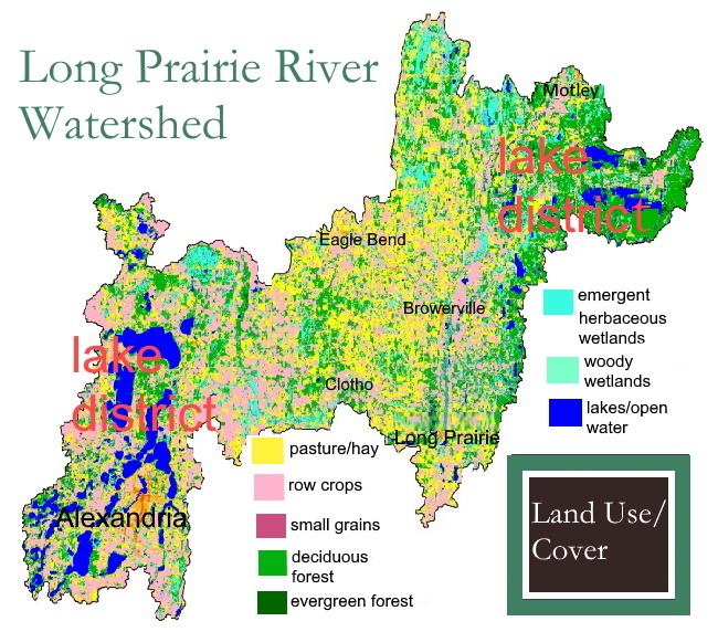
The Long Prairie River Region is a productive area with abundant natural resources. Local farmers and residents of small towns who live nearby benefit immensely from the bounty. The lakes near Alexandria and in other areas are a recreational resource used by locals and visitors alike. The work of glaciers, long since gone, still defines the landscape. Nature and humans have adapted well to this special environment.
![]()
Suggested Readings
Knaeble, A.R. Guidebook 22. Field Trip Guidebook Landforms, Stratigraphy, and Lithologic Characteristics of Glacial Deposits in Central Minnesota. St. Paul, Minn: Minnesota Geological Survey, 2006. Retrieved from the University of Minnesota Digital Conservancy, https://hdl.handle.net/11299/59145.
Lusardi, A.B. Minnesota at a Glance: Quaternary Glacial Geology. St. Paul: Minnesota Geological Survey, 1994. Revised 2017 by E.L Dengler.
Wright, Herbert Edgar. Geologic History of Minnesota Rivers. St. Paul, Minn.: University of Minnesota, 1990. Retrieved from the University of Minnesota Digital Conservancy, https://hdl.handle.net/11299/57272
Nature in Minnesota and Long Prairie River Watershed (Web pages by Minnesota Department of Natural Resources)
- Mammals in Minnesota (a partial list)
- Trees and Forests
- Rocks and Minerals
- Common Fishes of Minnesota
- Birds of Minnesota
- Plants of Minnesota
ABOUT THE AUTHOR
John Sandy, author of this technical report, is former head of Rodgers Library for Science and Engineering, The University of Alabama. He also was head of the Natural Resources Library, Natural Resources Research Institute, University of Minnesota Duluth, 1984-1991.
Permanent link to digital copy of this technical report

![]()
